This place has been the focus of my interest for the past few months. There's so much industrial history packed into this small area that there's always more to explore. It's been a multi-trip series with a lot more to come.
I read a local news article about a granite-brick vaulted drain tunnel built in the 1840s. The few blurry photos were tantalizing, so I made it my mission to find the tunnel and figure out what it was all about.
The Powers that Be bragged about keeping the location
Top Secret, but they helpfully included plenty of clues. Those, along with an old stormwater management plan and railroad documents, gave me some good ideas about where to look.
01: The Wallwe came in?
In the 1950s, the city was devastated by flooding. After that, the Army Corps of Engineers built this giant wall and some other flood protection projects.
Walking along these rocks was a tiring, ankle-twisting experience.
 02: Tiny Flap Gate
There were two of these little flap gates, overgrown and disused.
I propped the door open and crawled through a short section of 24" pipe, which then turned straight downward into a pump rotor. Dead end. Directly overhead, there's a pumping station.
 03: Huge Flap Gate
This huge cast iron door protected a 60" drain behind it, allowing stormwater to flow out and keeping floodwater from coming in.
 04: Inside the Huge Flap Gate
Thinking it would lead into the old brick tunnel, I came back with Saladking and some mechanical assistance to open the massive door.
On the other side of it was another big sluice gate. They really love their sluice gates here.
 05: Hell and High Water
All the debris on the ceiling shows how much this drain fills up during a storm. Anyone unfortunate enough to be caught inside would surely be killed to death.
 06: Up the pipe
happy lightpainting accident.
 07: Dropshaft
Water fell about 8 feet from here, making the whole drain incredibly loud.
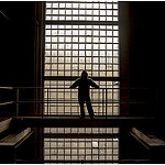
 08: Reflection
  09: End of the Line
All the water in this drain came from here, down from a grate box above. The whole drain was a straight shot from here to the end with no branches.
I climbed up below the grate to look at the buildings I could see, and came back in the daytime to find out where it was on the surface.

It was a cool drain (by my standards, at least), but it wasn't the granite-brick tunnel I was looking for. Dates marked on some of the pipes showed it was built in 1969-1970.
10: Sluice-Gate RoomNearby was this big room behind a giant sluice gate. Inside was an equally giant closed sluice gate, and two 36" pipes.
The closed gate leads down below the pump station, and there is absolutely no way I could open it.
Instead, I tried rolling up one of the 36" pipes on a skateboard.
 11: I am the Pipe Now
One of the wheels on my skateboard broke right away, and silt from the bottom of the pipe ruined the bearings. Even so, I made it up the pipe to this junction box.
When I saw the magic numbers, I knew I was going the right way. This number identifies the "bridge" where the railroad crosses the tunnel.
 12: In All Its Glory
Granite brick vaulted tunnel, just as promised! In this section, it was 6-7 feet tall.
 13: Enzo for Scale
The railroad "bridge". Nothing is visible on the surface but it's an undergrade bridge nonetheless.
This is why the tunnel made the local news in the first place. City engineers were sent down to inspect this bridge for the railroad company.
 14: Flume Thingy
One stretch had this little flume running down the side. Clearly this tunnel has had many uses since it was built almost 180 years ago.
 15: The Very(?) End
 It ends here, unless one wants to crawl through a little pipe of stagnant water.
It looks like there's a manhole above that big puddle, but I still don't know where this is on the surface. It's so tough to get a sense of distance and direction underground.
 16: Pipe Crossing
A slightly newer pipe cuts through.
 17: Exit
Now isn't this where

There were a few suggestions about what the tunnel was for, including transport of ammunition during the Civil war, a drain for street rainwater, even a secret passageway for the mob.
All of them were wrong. The tunnel was a tailrace, carrying outflow water from the wheels in the mills up above. I thought it looked like a tailrace at first, and later I got that confirmed.
18: New InformationThanks to a helpful librarian, I got this map from 1897 that showed the canal (which is mostly built over now), the tunnels, and the buildings as they existed back then.
It shows a Y-junction that connected to another tailrace, and the main tunnel keeps going north a lot further than I thought.
So where was the end of the tunnel I found? It might have been at the Y-junction, since I didn't notice any junction down there or any place where it might have been.
 19: The Very Very (??) End
 Continuing the path of the tunnel north off the edge of the map, and it looks like it would intersect one of the buildings in the mill complex above. In that building, there's the remains of a similar-looking tunnel that was bricked up and filled in a long time ago.

Could this have been part of the same tunnel? Did this building used to house turbines back in the 19th century?
Do any of the ~400 yards of tunnel between here and the former Y-junction still exist?
Maybe in a future explore, we'll find out.
Hope you enjoyed.