|
|
|
UER Store
|
|
 order your copy of Access All Areas today!
|
|
|
|
Activity
|
|
941 online
Server Time:
2024-05-04 16:06:30
|
|
|
 |
|
|
|
|
Location DB >
United States >
Texas >
San Antonio >
Comanche Lookout Park
|
|
Log in to activate viewing options
|
|
|
created by Allva
on 10/22/2004 12:13 AM
last modified by Allva
on 4/22/2007 3:32 PM
|
|
 |
Publically Viewable |
|
This location has been labeled by its creator as Public, and therefore can be viewed by anyone.
|
|
|
|
|
|
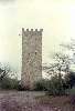
Based on a large hill, with a visible ,prominent tower at it's peak.
|
|
|
Type: Outdoors
Status: Demolished and reconstructed as a park
Accessibility: Easy...it's a park...duh..
Recommendation: not very exciting, now....good cardio workout
|
|
|
|
|
|
It's a nice hiking park now, but the most interesting feature is it's history and the way it used to look .
|
|
|
none...once again, it's a park!
|
|
|
|
|
|
|
Comanche Lookout Park is a 96-acre public park owned by the City of San Antonio. The site includes the fourth highest point in Bexar County with an elevation of 1,340 feet. The Cibolo floodplain lies at the base of this escarpment between the Gulf Coastal Plain and the Edwards Plateau. Vegetation on the hill includes native ash juniper, Texas and Mexican buckeye, chinaberry, graneno, Lindheimer hackberry, honey mesquite and huisache.
Native Americans used this hill as a vantage point for warfare and hunting. The Apache, and later, the Comanche Indians dominated the area as they hunted along waterways including nearby Cibolo Creek. The hill was also a prominent landmark for travelers in the 18th and 19th centuries. The old Spanish road (one of several routes of the Camino Real or Royal Road) from San Antonio to Bastrop and Nacogdoches in East Texas extended past the base of the hill. The road followed earlier American Indian travel routes, and today its remnants are known as Nacogdoches Road.
The land surrounding and including Comanche Lookout was part of Land Grant Survey #196 comprised of 1,476 acres that was surveyed for James Conn in April 1847. The property subsequently had a number of owners including Peter W. Gray, Alexander Patrick, and Ludovic Colquhoun. Frequent sale of land grants was not uncommon during the Republic and early Statehood periods in mid-19th century Texas.
The Comanche Lookout property was acquired by Mirabeau B. Lamar in September 1848. Lamar served as second president of the Republic of Texas (1838-41) and enjoyed a long and distinguished political, military and diplomatic career. It is not clear why Lamar purchased the land described in his deed as "including the hill known as Comanche Lookout." The property was inherited by Lamar’s daughter by his second marriage, Loretto Evalina (1852-1933) who was only seven years old when her father died in 1859. She later married Samuel Douglass Calder, also a member of a prominent Texas family. The Calders lived in Galveston and apparently did not use the Comanche Lookout property. In July 1890, they sold 524.6 acres of the land to German immigrants, Gustav and Adolph Reeh of Bexar County for $3,500. The Reeh brothers used the land for farming. After Adolph Reeh died, Gustav sold a portion of his land to retired Army Colonel Edward H. Coppock in February 1923 for $6,000.
Coppock was a romantic and history aficionado, and with assistance from his two sons and a man named Tarquino Cavazos, he constructed an extensive compound on the hill including a four-story, medieval-style stone tower. Coppock envisioned a castle-like house, but completed only its foundation. Both he and Mr. Cavasos died in 1948 and the project was abandoned. Colonel Coppock’s children sold the land in 1968 to a developer who cleared all of the structures except for the tower and some remnant foundations.
The property traded hands several times before the real estate market collapse of the 1980s led to the Resolution Trust Corporation’s ownership of the remaining Comanche Lookout property in 1990. At that time, a private sector effort was organized to preserve the site led by a group named Save Comanche Lookout. This resulted in the Trust for Public Lands providing an interim loan to the City of San Antonio to purchase Comanche Lookout for a City park. The loan was repaid through the 1994 General Obligation Bond package.
The 1994 Bond package provided $1.4 million for acquisition and development of the site. In 1995, the Parks and Recreation Department retained landscape architectural consultant, Laffoon Associates, to analyze the site and develop a conceptual plan that would preserve the park’s natural and cultural assets. The first phase of development included construction of off-street parking, level 1 and 2 accessible trails, and service roads, and installation of drinking fountains. The second phase of development will be funded with $762,300 from the 1999 Bond election. It will be completed in conjunction with construction of a branch library on the perimeter of the park at Judson and Nacogdoches Roads. Scheduled for 2003-04, Phase 2 will include additional parking improvements and trails, picnic and restroom facilities, landscaping and site work.
The posted were taken in the late 80's before City of San Antonio took over. This is how Comanche Lookout Park used to look...This is how most people who grew up in that area in the 80's remember this site. You are seenig the past. Enjoy!
|
|
|
|
|
|
|
|
|
|
|
|
|
The moderator rating is a neutral rating of the content quality, photography, and coolness of this location.
This location has not yet been rated by a moderator.
|
|
 This location's validation is current. It was last validated by
Emperor Wang on 4/22/2007 5:57 PM.
This location's validation is current. It was last validated by
Emperor Wang on 4/22/2007 5:57 PM.
|
|
|
on Apr 22 07 at 17:57, Emperor Wang validated this location
on Apr 22 07 at 15:32, Allva changed the following: Web Links
on Nov 11 05 at 23:06, Allva updated gallery Update:Comanche Lookout Park today
on Aug 9 05 at 23:24, Allva changed the main information
on Aug 9 05 at 23:23, Allva made this location public
on Aug 4 05 at 1:43, Allva updated basic gallery info
on Aug 4 05 at 1:43, Allva updated basic gallery info
on Aug 4 05 at 1:35, Allva updated basic gallery info
on Oct 31 04 at 12:53, Allva updated a gallery picture
on Oct 31 04 at 12:52, Allva updated a gallery picture
|
|
|
|
|
|
|
Is this location inappropriate / broken / missing key info?
If it's something you can fix, please scroll up and click the EDIT button.
If this location was only posted a few days ago, give the creator time to work on it.
Please try sending a message directly to the creator of the location. You'll find that info at the top of this page.
Otherwise, ONLY if you've already tried to contact the original creator,: Click here to notify an administrator.
|
|
|
|
All content and images copyright © 2002-2024 UER.CA and respective creators. Graphical Design by Crossfire.
To contact webmaster, or click to email with problems or other questions about this site:
UER CONTACT
View Terms of Service |
View Privacy Policy |
Server colocation provided by Beanfield
This page was generated for you in 125 milliseconds. Since June 23, 2002, a total of 740492346 pages have been generated.
|
|