|
|
|
UER Store
|
|
sweet UER decals:

|
|
|
|
Activity
|
|
813 online
Server Time:
2024-04-19 05:19:13
|
|
|
 |
|
|
|
|
Location DB >
Canada >
British Columbia >
Sooke >
Deer Trails
|
|
Log in to activate viewing options
|
|
|
created by lopix
on 8/6/2005 11:26 PM
last modified by -Rio-
on 4/29/2015 8:38 AM
|
|
 |
Publically Viewable |
|
This location has been labeled by its creator as Public, and therefore can be viewed by anyone.
|
|
|
|
|
|
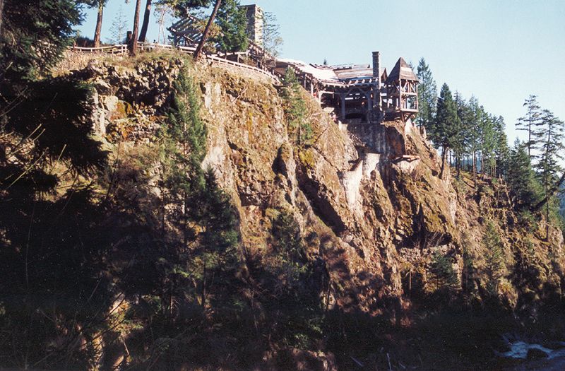
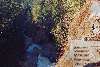
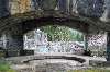
Large unfinished resort perched high on a cliff overlooking a small river. Contained with the Sooke Potholes Provincial Park. Massive timber framing and stonework are all that ever got finished. Basement was full of little rooms, almost like a stable, but seemed very creepy. Lots of stone paths and stairs to take you down to the river and to a small waterfall.
|
|
|
Type: Building
Status: Demolished (idiots!)
Accessibility: Easy - but only the foundations and some stone walls remains
Recommendation: check it out if you're nearby
|
|
|
Address
Sooke river road
Sooke, British Columbia
Canada
Owner: The Land Conservancy and Capital Regional District Parks
See a map of this location
|
|
|
unsafe flooring
squatters, creepy hippies, cougars/bears
|
|
|
massive timbers
enormous fireplace
creepy-ass basement catacombs
nifty stone stairs and paths
nice river and waterfall
amazing view
|
|
|
fences
barbed wire
locked gates
|
|
|
|
|
|
|
When Albert Yuen acquired the property he saw the potential of the spectacular outcropping as the site for a world class resort and conference centre. It was touted as a $50 million development that would provide employment for 150.
As time went on and the initial funding assistance from a government program was completed, the resort construction of stone and old growth timber was stalled. While his plans for the dramatic location drew the interest of architects and investors from around the world, it appeared that a meeting of the minds between Yuen and potential investors did not occur.
Many visitors were drawn to the DEER TRAIL site to witness the partially-built enterprise which included a stone cavern barbecue large enough to roast an ox. But in time, deterioration of materials unprotected from the weather led to concerns for safety.
In 2004, after a series of changes in plans and zoning, and financing issues, the property was acquired by The Land Conservancy and the Capital Regional District as parkland, and the Yuen dream came crashing to an end. Partial dismantling of the lodge structure followed and today little remains but stonework.
|
|
|
|
|
Diddly, bastards already tore it down
|
|
|
|
|
|
|
|
|
|
The moderator rating is a neutral rating of the content quality, photography, and coolness of this location.
| Category |
Rating |
| Photography |
7 / 10 |
| Coolness |
7 / 10 |
| Content Quality |
7 / 10 |
|
|
 This location's validation is current. It was last validated by
Explorer Zero on 8/29/2017 9:28 PM.
This location's validation is current. It was last validated by
Explorer Zero on 8/29/2017 9:28 PM.
|
|
|
on Aug 29 17 at 21:28, Explorer Zero validated this location
on Aug 29 17 at 19:51, EPOCH6 added some pictures to a gallery
on Aug 29 17 at 19:50, EPOCH6 added some pictures to a gallery
on Aug 29 17 at 19:48, EPOCH6 updated gallery August 26th, 2017 - Walkthrough
on Aug 29 17 at 19:48, EPOCH6 created a new gallery
on May 11 15 at 15:32, Mike Dijital validated this location
on Apr 29 15 at 8:38, -Rio- changed the following: Street Address, Year Closed, Accessibility
on Apr 29 15 at 8:29, -Rio- changed the following: Required Equipment, Media Coverage
on Apr 29 15 at 8:27, -Rio- changed the following: Owner, History, Year Closed, Interesting Features, Recommendation, Security Measures, Media Coverage
on Apr 29 15 at 1:12, -Rio- updated gallery picture
|
|
|
|
|
|
|
Is this location inappropriate / broken / missing key info?
If it's something you can fix, please scroll up and click the EDIT button.
If this location was only posted a few days ago, give the creator time to work on it.
Please try sending a message directly to the creator of the location. You'll find that info at the top of this page.
Otherwise, ONLY if you've already tried to contact the original creator,: Click here to notify an administrator.
|
|
|
|
All content and images copyright © 2002-2024 UER.CA and respective creators. Graphical Design by Crossfire.
To contact webmaster, or click to email with problems or other questions about this site:
UER CONTACT
View Terms of Service |
View Privacy Policy |
Server colocation provided by Beanfield
This page was generated for you in 78 milliseconds. Since June 23, 2002, a total of 738470176 pages have been generated.
|
|