|
|
|
UER Store
|
|
 order your copy of Access All Areas today!
|
|
|
|
Activity
|
|
667 online
Server Time:
2024-04-19 00:37:43
|
|
|
 |
|
|
|
|
Location DB >
United States >
Texas >
Houston >
The Ship Channel
|
|
Log in to activate viewing options
|
|
|
 |
Publically Viewable |
|
This location has been labeled by its creator as Public, and therefore can be viewed by anyone.
|
|
|
|
|
|
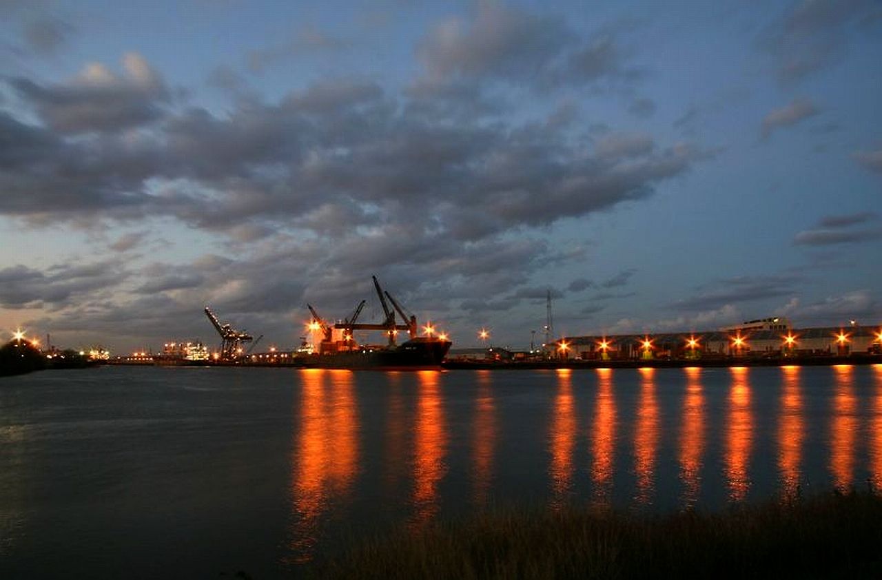
About 52 miles of navigable commercial waterways which includes man made channels as well as natural rivers, bays and bayous.
The port handles over 215 million tons of cargo each year and is the home of over 150 businesses including many petrochemical plants and refineries.
Its only fair to point out that the Federal government regulates a lot of what goes on here maybe as much if not more than the State of Texas does.
|
|
|
Type: Outdoors
Status: Active
Accessibility: Difficult, small craft are prohibited
Recommendation: worth the trip
|
|
|
|
water
large ocean going vessels, toxic chemicals
|
|
|
Lots of abandoned buildings, derelict ships, warehouses, refineries, depots, wharves, too many to list.
|
|
|
fences
barbed wire
razor wire
dogs
part-time guard
24 hour guard
locked gates
cameras
Just about every security measure you can imagine is employed here including but not limited to remote controlled cameras, infra-red cameras, sonar, radar, radiation detectors, active USCG and POHA patrols and real time vessel tracking via satellite
|
|
|
|
A pair of big brass ones would help
|
|
|
A car, light truck or motorcycle is helpful, a power boat, kayak or rubber dingy would be of no use this port is closed to all non-official small craft and recreational boat traffic
|
|
|
Commercial shipping started here in 1837 by the official record but mariners have sailed here even before then. Indians, pirates, fisherman all navigated the San Jacinto River and Buffalo Bayou in search of food, trade and treasure. Today its one of the Nations busiest commercial seaports.
In 1842 Houston established The Port of Houston and allowed construction of wharves and the removal of obstructions but nearby Galveston remained the primary port of entry and soon Houston financial interests grew weary of paying the high fees Galveston wharf authorities demanded.
In 1870 the U.S. Army Corp of Engineers undertook the widening and dredging of The Channel to 100ft wide and one fathom average depth (hardly enough draw for anything larger than a flat bottom river boat). By 1914 the channel averaged 25ft deep but further development ended with the U.S. entry into WWI.
By 1930 nine oil refineries had been built along the narrow waterway making it easy to transport the millions of barrels of petroleum products, etc, etc, this goes on through WWII and its all kind of boring unless youre a shipping history buff. Whats important to know now is this was the beginning of a major environmental disaster for the area and widening it and dredging it to more than 45ft deep made it a deep water port so very large vessels were using it now and its been growing and getting more polluted ever since.
The Port of Houston is a major thread in the economic fabric of the United States and this is why security is so high and has gotten even more severe since 9/11. Nevertheless The Houston Ship Channel continues to offer some excellent opportunities for the careful explorer such as this one: http://www.uer.ca/...ow.asp?locid=26240
EDIT: I made this public in the hope that someday, somebody will put on an orange life vest take a clipboard and hard hat then walk around the place like they owned it and get some better shots. I had second thoughts about suggesting anyone try exploring here because of the high level or enforcement and draconian penalties if caught. It remains one of Houston's iconic locations.
|
|
|
|
|
It will continue to be a seaport, I don't see it being used as anything else, its just too polluted for a water park.
|
|
|
|
|
|
|
|
|
|
The moderator rating is a neutral rating of the content quality, photography, and coolness of this location.
| Category |
Rating |
| Photography |
8 / 10 |
| Coolness |
9 / 10 |
| Content Quality |
8 / 10 |
|
|
 This location's validation is current. It was last validated by
Mike Dijital on 10/24/2014 11:44 PM.
This location's validation is current. It was last validated by
Mike Dijital on 10/24/2014 11:44 PM.
|
|
|
on Oct 24 14 at 23:44, Mike Dijital validated this location
on Oct 22 14 at 23:24, Explorer Zero changed the following: Web Links
on Oct 22 14 at 13:17, Explorer Zero changed the following: Security Measures, Recommended Equipment, Description
on Oct 22 14 at 13:07, Explorer Zero updated gallery picture I dont got to show you no bridges
on Oct 22 14 at 13:06, Explorer Zero updated gallery picture The Gold Indus
on Oct 22 14 at 13:05, Explorer Zero updated gallery picture The Pacific Java
on Oct 22 14 at 13:04, Explorer Zero updated gallery picture The Navalmar
on Oct 22 14 at 13:04, Explorer Zero updated gallery picture Tower crane
on Oct 22 14 at 13:03, Explorer Zero updated gallery MARSEC LEVEL 1
on Oct 22 14 at 13:01, Explorer Zero changed the following: Notes for Mods, History, Accessibility, Interesting Features, Security Measures, Required Equipment, Future Plans, Description
|
|
|
|
|
|
|
Is this location inappropriate / broken / missing key info?
If it's something you can fix, please scroll up and click the EDIT button.
If this location was only posted a few days ago, give the creator time to work on it.
Please try sending a message directly to the creator of the location. You'll find that info at the top of this page.
Otherwise, ONLY if you've already tried to contact the original creator,: Click here to notify an administrator.
|
|
|
|
All content and images copyright © 2002-2024 UER.CA and respective creators. Graphical Design by Crossfire.
To contact webmaster, or click to email with problems or other questions about this site:
UER CONTACT
View Terms of Service |
View Privacy Policy |
Server colocation provided by Beanfield
This page was generated for you in 93 milliseconds. Since June 23, 2002, a total of 738450898 pages have been generated.
|
|