|
|
|
UER Store
|
|
 order your copy of Access All Areas today!
|
|
|
 |
|
|
|
|
Location DB >
United States >
California >
Monterey >
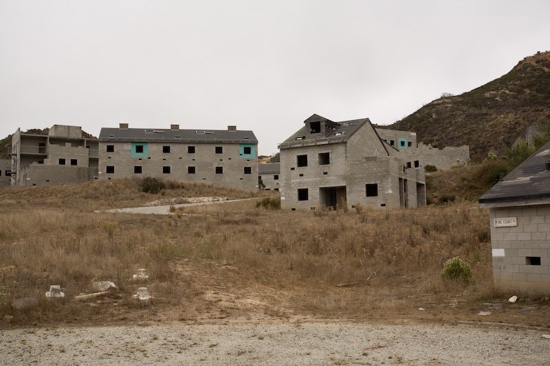
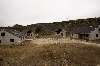
Impossible City
|
|
Log in to activate viewing options
|
|
|
 |
Publically Viewable |
|
This location has been labeled by its creator as Public, and therefore can be viewed by anyone.
|
|
|
|
|
|
An entire "city" built of cinder-block buildings with concrete flooring. Everything ranging from 1-story "houses", 2-story houses, a "city hall", "hotel", gas stations with old pumps, some buildings with basements, sewer drain systems with off-site entry that lead to manholes in the "city", bleachers for training "class" troop formation, a training building with a complete raised-relief map of the area, a "tire maze" for live round assault training, totaled wrecked van (forgot to get a photo of it, though... we walked by it on the way in while scoping the area out and planned to get photos of it, but it started raining on us!). The wrecked van looked like it was right out of a scene from a bombed Iraqi city.
|
|
|
Type: Outoor / Indoor
Status: Occasionally Active
Accessibility: Moderate "and then some"
Recommendation: worth the trip
|
|
|
|
|
|
An entire training complex "city" built of cinder-block buildings with concrete flooring. Complete timeless post-apocalyptic and post-war "feel".
|
|
|
fences
barbed wire
razor wire
part-time guard
locked gates
frequent DOI Ranger patrols
|
|
|
|
flashlight
gloves
long pants / sleeves
bicycle (can't park nearby... only hike and bike)
|
|
|
|
Originally part of Fort Ord, this area is so really remote that it deserves its own LDB entry and not just part of "Fort Ord".
The area was developed during the 1980's by the 7th Infantry division and utilized as an advanced training area. The training area included a small town (called Dodge City) that had pop up shooting targets of bad guys and good guys. In the 1980's the Impossible City was built to train the infantry in urban assault tactics.
Impossible City derives its name from the way the city is built, all areas can be easily seen from adjacent buildings, and most doors open to a central area. Today the facility is run and used by the "eff_bee_eye" for urban training. They sublease the area to local law enforcement agencies and military units such as the Navy Seals. This area is off limits to the general public.
|
|
|
|
|
|
|
|
|
|
|
|
|
The moderator rating is a neutral rating of the content quality, photography, and coolness of this location.
| Category |
Rating |
| Photography |
7 / 10 |
| Coolness |
7 / 10 |
| Content Quality |
7 / 10 |
|
|
 This location's validation is current. It was last validated by
Emperor Wang on 10/5/2023 9:27 PM.
This location's validation is current. It was last validated by
Emperor Wang on 10/5/2023 9:27 PM.
|
|
|
on Oct 5 23 at 21:27, Anonymous validated this location
on Oct 5 23 at 21:27, Anonymous changed the following: Type, History, Interesting Features, Required Equipment, Media Coverage, Future Plans, Description
on Oct 5 23 at 14:37, Anonymous changed the following: Latitude, Longitude, Co-ordinate Accuracy, Prefer Satellite
on Aug 19 17 at 15:46, Anonymous validated this location
on Aug 19 17 at 6:17, Anonymous made this location public
on Feb 24 09 at 3:09, Anonymous validated this location
on Feb 23 09 at 23:47, Anonymous changed the following: Interesting Features, Description
on Nov 12 08 at 14:06, Anonymous validated this location
on Nov 12 08 at 7:07, Anonymous updated gallery picture IMG_0200
on Nov 12 08 at 7:07, Anonymous updated gallery picture IMG_0198
|
|
|
|
|
|
|
Is this location inappropriate / broken / missing key info?
If it's something you can fix, please scroll up and click the EDIT button.
If this location was only posted a few days ago, give the creator time to work on it.
Please try sending a message directly to the creator of the location. You'll find that info at the top of this page.
Otherwise, ONLY if you've already tried to contact the original creator,: Click here to notify an administrator.
|
|
|
|
All content and images copyright © 2002-2024 UER.CA and respective creators. Graphical Design by Crossfire.
To contact webmaster, or click to email with problems or other questions about this site:
UER CONTACT
View Terms of Service |
View Privacy Policy |
Server colocation provided by Beanfield
This page was generated for you in 125 milliseconds. Since June 23, 2002, a total of 739731625 pages have been generated.
|
|