|
|
|
|
|
Location DB >
United States >
South Carolina >
Greenville County >
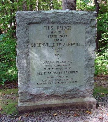
Poinsett Bridge
|
|
Log in to activate viewing options
|
|
|
created by jeepdave
on 5/25/2010 10:45 PM
last modified by fr00tCake
on 1/26/2023 6:31 PM
|
|
 |
Publically Viewable |
|
This location has been labeled by its creator as Public, and therefore can be viewed by anyone.
|
|
|
|
|
|
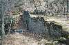
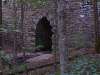
Bridge. Not very big. Easy to access. Beautiful.
|
|
|
Type: Outdoors
Status: Repurposed
Accessibility: Easy
Recommendation: check it out if you're nearby
|
|
|
|
|
|
Very old bridge with Gothic Arch. Was on the road to Ashville NC. Many stories associated with bridge. Public hiking trail in area and bridge is public access.
|
|
|
None, visitors are encouraged.
|
|
|
|
flashlight
long pants / sleeves
CAMERA A MUST. Easy to photograph.
|
|
|
|
Old Bridge with Gothic Arch. Very good condition for age
|
|
|
Much, with historical societys.
|
|
|
|
|
|
|
|
|
|
|
The moderator rating is a neutral rating of the content quality, photography, and coolness of this location.
This location has not yet been rated by a moderator.
|
|
 This location's validation is current. It was last validated by
Emperor Wang on 1/27/2023 1:02 AM.
This location's validation is current. It was last validated by
Emperor Wang on 1/27/2023 1:02 AM.
|
|
|
on Jan 27 23 at 1:02, Emperor Wang validated this location
on Jan 26 23 at 18:31, fr00tCake changed the following: Latitude, Longitude, Prefer Satellite
on Nov 4 11 at 15:02, Opheliaism validated this location
on Nov 4 11 at 4:02, jeepdave added some pictures to a gallery
on Nov 4 11 at 3:57, jeepdave updated gallery My photos from way back when
on Nov 4 11 at 3:57, jeepdave created a new gallery
on Jun 8 11 at 16:38, Emperor Wang validated this location
on Mar 7 11 at 10:19, Steed conditionally validated this location
on Dec 6 10 at 23:26, Steed conditionally validated this location
on Sep 2 10 at 14:09, Steed conditionally validated this location
|
|
|
|
|
|
|
Is this location inappropriate / broken / missing key info?
If it's something you can fix, please scroll up and click the EDIT button.
If this location was only posted a few days ago, give the creator time to work on it.
Please try sending a message directly to the creator of the location. You'll find that info at the top of this page.
Otherwise, ONLY if you've already tried to contact the original creator,: Click here to notify an administrator.
|
|
|

 order your copy of Access All Areas today!