|
|
|
UER Store
|
|
 order your copy of Access All Areas today!
|
|
|
|
Activity
|
|
716 online
Server Time:
2024-04-19 14:38:21
|
|
|
 |
|
|
|
|
Location DB >
United States >
South Carolina >
Spartanburg >
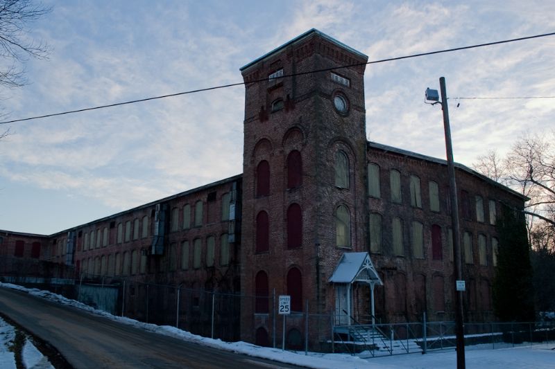
Clifton Mill #2
|
|
Log in to activate viewing options
|
|
|
created by Crypton
on 1/16/2011 1:17 AM
last modified by Crypton
on 11/5/2014 11:15 PM
|
|
 |
Publically Viewable |
|
This location has been labeled as Demolished, and therefore can be viewed by anyone.
|
|
|
|
|
|
Demolished some time in 2013-2014.
-- Original Description --
Great location in a fairly secluded place. Doubtful of the land value if it rises making the owner tare it down. 5 floor (incl. basement) structure contains lots and lots of empty barrels, chairs, and other rubbish. The grass is mowed, so the owners keep a close eye on the property. There is certainly water damage in upper floors. Broken glass in few places, otherwise dust is the only problem. Most light fixtures in place and have bulbs. There is a small and active substation on the property, but none of the buildings seem to have power connected. One of the recent notes is a Dish Network satellite antenna on the wall on the office building.
--
Looks like a group of paranormal investigators were here in the mid 2000s to check the place out and deemed it 'haunted' check out web links (site no longer available, pulled from web archive).
|
|
|
Type: Building
Status: Demolished
Accessibility: Moderate
Recommendation: forget it
|
|
|
|
asbestos
unsafe flooring
water
air quality
lead paint, high traffic area
|
|
|
Situated directly on top of pacolet river. Has a original building, adjacent warehouse & office building, power house. You can see pillars of an old steel bridge on each side of river. The outside has a cool dam on the river
|
|
|
fences
barbed wire
locked gates
welded doors
|
|
|
|
flashlight
breathing mask
gloves
long pants / sleeves
|
|
|
|
The first large mill in the district was constructed about 50 years after the Revolutionary War. The man at the center of the development was Dr. James Bivings, about 1832. The community took the name Bivingsville. Records indicate that the mill was sold for $19,500 in bankruptcy proceedings in 1856. A group that included Dexter Edgar Converse bought the mill. Converse was chosen as manager of the mill. After the Civil War, Converse became the principal owner of the property. In 1880, apparently at the urging of Converse’s wife, Helen, the name of the village was changed from Bivingsville to Glendale.
In the 1880s, D.E. Converse & Company bought property on the Pacolet River and expanded beyond the mill at Glendale. In 1881, the first mill of Clifton Manufacturing Company was opened. In 1889, Clifton Mill No. 2 began operation about three-fourths of a mile below No. 1.
|
|
|
|
|
Demolished some time in 2013-2014.
|
|
|
|
|
|
|
|
|
|
The moderator rating is a neutral rating of the content quality, photography, and coolness of this location.
| Category |
Rating |
| Photography |
8 / 10 |
| Coolness |
8 / 10 |
| Content Quality |
8 / 10 |
|
|
 This location's validation is current. It was last validated by
Mike Dijital on 11/9/2014 2:29 AM.
This location's validation is current. It was last validated by
Mike Dijital on 11/9/2014 2:29 AM.
|
|
|
on Nov 9 14 at 2:29, Mike Dijital validated this location
on Nov 5 14 at 23:15, Crypton changed the following: Notes for Mods, Publically Viewable, Status, Recommendation, Future Plans, Description
on Feb 15 12 at 19:15, Opheliaism validated this location
on Feb 15 12 at 19:12, Crypton changed the following: Latitude, Longitude, Co-ordinate Accuracy
on Feb 8 12 at 3:26, Opheliaism validated this location
on Feb 8 12 at 1:30, Crypton changed the following: Street Address, Latitude, Longitude, Co-ordinate Accuracy
on Apr 26 11 at 12:55, Opheliaism validated this location
on Apr 25 11 at 1:20, Crypton changed the following: Interesting Features
on Apr 25 11 at 1:18, Crypton updated gallery picture IMG_2049
on Apr 25 11 at 1:17, Crypton updated gallery picture IMG_2048
|
|
|
|
|
|
|
Is this location inappropriate / broken / missing key info?
If it's something you can fix, please scroll up and click the EDIT button.
If this location was only posted a few days ago, give the creator time to work on it.
Please try sending a message directly to the creator of the location. You'll find that info at the top of this page.
Otherwise, ONLY if you've already tried to contact the original creator,: Click here to notify an administrator.
|
|
|
|
All content and images copyright © 2002-2024 UER.CA and respective creators. Graphical Design by Crossfire.
To contact webmaster, or click to email with problems or other questions about this site:
UER CONTACT
View Terms of Service |
View Privacy Policy |
Server colocation provided by Beanfield
This page was generated for you in 78 milliseconds. Since June 23, 2002, a total of 738508094 pages have been generated.
|
|