|
|
|
UER Store
|
|
sweet UER decals:

|
|
|
|
Activity
|
|
972 online
Server Time:
2024-04-25 10:30:25
|
|
|
 |
|
|
|
|
Location DB >
United States >
Massachusetts >
Newburyport >
Train Bridge
|
|
Log in to activate viewing options
|
|
|
 |
Publically Viewable |
|
This location has been labeled by its creator as Public, and therefore can be viewed by anyone.
|
|
|
|
|
|
|
|
Type: Outdoors
Status:
Accessibility:
Recommendation:
|
|
|
|
|
|
|
|
|
|
|
|
|
|
|
Newburyport
Proposed Rail-trail
The Newburyport MBTA Station was constructed a few years ago on an entirely new location for the Newburyport
extension of a MBTA Commuter Rail line that had previously terminated in Ipswich.
There is no evidence of trail usage on the railroad right-of-way between Parker and Low Streets. Note also that the
railroad overpass at Low street is missing, and there is no sign of a trail at that crossing. A sign was noted for a
pedestrian route to downtown Newburyport, at the intersection of Parker street just east of the north entrance to
the railroad station.
A single track trail presumably begins at the side of the Henry Graf, Jr. Skating Rink at 28 Low Street, and continues
north on the railroad right of way to the Washington Street crossing (Mapblast map). The block between
Washington Street and the Merrimack Street Overpass has been transformed by neighborhood volunteers into a
small park. Since the old B&M RR station was located at midpoint of this block, all historic railroad mileage figures
for Newburyport apply at that point.
The trail then overpasses Merrimack Street and continues on a high railroad embankment to a dead end at the
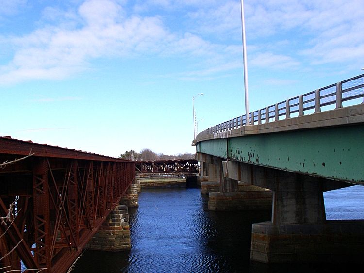
Merrimack River. Note that the railroad bridge is an old-fashioned swing bridge which has been abandoned in the
'open' position. The Route 1 highway bridge is perhaps a decade or so old and is thus four lanes wide in what is
otherwise a two lane highway. Thus it may be possible to block off one southbound lane of the highway bridge for
trail purposes.
|
|
|
|
|
|
|
|
|
|
|
The moderator rating is a neutral rating of the content quality, photography, and coolness of this location.
| Category |
Rating |
| Photography |
6 / 10 |
| Coolness |
6 / 10 |
| Content Quality |
5 / 10 |
|
|
 This location's validation is current. It was last validated by
Mike Dijital on 9/26/2015 4:38 PM.
This location's validation is current. It was last validated by
Mike Dijital on 9/26/2015 4:38 PM.
|
|
|
on Sep 26 15 at 16:38, Mike Dijital validated this location
on Sep 26 15 at 16:38, Mike Dijital added some pictures to a gallery
on Sep 26 15 at 16:37, Mike Dijital created a new gallery
on Sep 26 15 at 16:37, Mike Dijital made this location available
on Sep 26 15 at 16:37, Mike Dijital updated the main picture
on Sep 26 15 at 16:36, Mike Dijital changed the following: Notes for Mods, Type, Street Address, City, Province / State (please use full name), Country, Latitude, Longitude, Co-ordinate Accuracy, Prefer Satellite, Publically Viewable, History, Interesting Features, Media Coverage, Future Plans, Description, Web Links
|
|
|
|
|
|
|
Is this location inappropriate / broken / missing key info?
If it's something you can fix, please scroll up and click the EDIT button.
If this location was only posted a few days ago, give the creator time to work on it.
Please try sending a message directly to the creator of the location. You'll find that info at the top of this page.
Otherwise, ONLY if you've already tried to contact the original creator,: Click here to notify an administrator.
|
|
|
|
All content and images copyright © 2002-2024 UER.CA and respective creators. Graphical Design by Crossfire.
To contact webmaster, or click to email with problems or other questions about this site:
UER CONTACT
View Terms of Service |
View Privacy Policy |
Server colocation provided by Beanfield
This page was generated for you in 78 milliseconds. Since June 23, 2002, a total of 739061334 pages have been generated.
|
|