forums
new posts
donate
UER Store
events
location db
db map
search
members
faq
terms of service
privacy policy
register
login


Location DB > Canada > Quebec > Montreal > Glen Yards > Overlay > map_and Photo_croped.jpg

1 / 1   map_and Photo_croped.jpg

Description
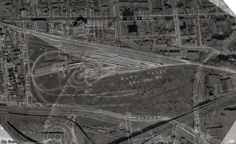
This a combination of the sattelite picture and the CP Rail diagram.

You can see the location of the roundhouse and other parts of the Glen Yards. You can also see the location of streets that were changed or added
Controls

Return to Main Location Page

Return to Gallery Overview

Edit this Gallery

Edit this Picture

Un-Subscribe this Picture
Comments
Posted by Emperor Wang 5/15/2005 4:02 AM | remove
  Photoshop at its best!
Posted by nostra-YOUPPI! 5/15/2005 6:38 AM | remove
  if you look closely the old passenger car prep yard had yet to be built, the street just east of the cn roundhouse is not placed correctly on the map as the building it chops in half is almost a 75 years old
Posted by TaP 5/15/2005 4:41 PM | remove
  where glen yard is written, you can see the abandonned tracks, why arent they in the drawing/map
Posted by nostra-YOUPPI! 5/15/2005 4:55 PM | remove
  yeah that was the prep yard in the 50s where great name trains like the canadian were fiddled,
If you'd like to add a comment, please login or register.


All content and images copyright © 2002-2024 UER.CA and respective creators. Graphical Design by Crossfire.
To contact webmaster, or click to email with problems or other questions about this site: UER CONTACT
View Terms of Service | View Privacy Policy | Server colocation provided by Beanfield
This page was generated for you in 312 milliseconds. Since June 23, 2002, a total of 738444311 pages have been generated.