forums
new posts
donate
UER Store
events
location db
db map
search
members
faq
terms of service
privacy policy
register
login


UER Forum > Private Boards Index > Cartography & Geography > newb GIS mapping question. (Viewed 3648 times)
Blargo 


Location: Guelph, ON
Gender: Male
Total Likes: 0 likes


 |  |  | Add to ICQ
newb GIS mapping question.
< on 2/11/2005 9:08 PM >
Reply with Quote
Posted on Forum: UER Forum
I don't know if anyone will be able to help me out with this, but I'm going to give it a shot anyway.
I'm trying to open an abandoned mines database (http://www.mndm.gov.on.ca/mndm/mines/mg/abanmin/abandata_e.asp) but I have no clue how to do this. I have access to the ARCview software, but I can't figure out which program to use (ARC map, ARC reader, etc.) and which files to open within the database. I've unzipped everything and tried to open/search for the files that ARCview apparently uses but with no luck. Any help would be appreciated!


Chainsaw 

This member has been banned. See the banlist for more information.


Location: Underground, Colorado
Gender: Male
Total Likes: 0 likes


 |  |  | Subciety
Re: newb GIS mapping question.
< Reply # 1 on 2/11/2005 10:31 PM >
Reply with Quote
Posted on Forum: UER Forum
What's the extension of the file you are trying to open?


Quid latine dictum sit, altum sonatur.
Blargo 


Location: Guelph, ON
Gender: Male
Total Likes: 0 likes


 |  |  | Add to ICQ
Re: newb GIS mapping question.
< Reply # 2 on 2/12/2005 12:51 AM >
Reply with Quote
Posted on Forum: UER Forum
which file type should I be looking to open? 
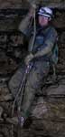
There's a bunch of .tbl, .prj, .shx, .shp, .dbf, and .xls files (although I think .xls is an Excel file...)


NYMartian 


Location: Rockland County
Gender: Male
Total Likes: 0 likes


 |  |  | Whats in the forest
Re: newb GIS mapping question.
< Reply # 3 on 2/21/2005 4:28 AM >
Reply with Quote
Posted on Forum: UER Forum
Ok, here it is. I wrote this in AIM to myself when doing it to make sure I got it correct. I am copying and pasting it from there to here. Please no comments on spelling or capitalization.

First:
Create a new project with a new view
It will ask if you want to create a new theme now. Select yes

Then select the shp file that you have from the data you downloaded

This will now appear on the side bar. You need to select the check box for it to be visible

I am assuming that you would like to be able to select a given location from the database and have it displayed for you by arcview

to do this, go to the Theme->Table, and the table will be opened. It will appear in the tables menu of the main project as "Attributes of _______.shp
The table is the .dbf file you have. It is automatically opened. You do not need to select it or anything.

To get to it, go to Window->Untitled, and go to Tables. You can open it from here, though it will automatically be opened when you first create it. You will likely be able to just go to Window->Attributes of _______.shp

you can search and select the desired location here. you can select multiple locations too

make sure the desired shp file is selected on the side bar

then go to View->Zoom to selected

You should be able to take it from here. I hope this information was a help to you. ArcView and other GIS software really can be a godsend to UE. I use it frequently for planning UE.


oh-ten 


Location: San Francisco CA
Gender: Male
Total Likes: 6 likes


 |  | 
Re: newb GIS mapping question.
< Reply # 4 on 11/17/2005 4:29 AM >
Reply with Quote
Posted on Forum: UER Forum
Posted by NYMartian
Ok, here it is. I wrote this in AIM to myself when doing it to make sure I got it correct. I am copying and pasting it from there to here. Please no comments on spelling or capitalization.

First:
Create a new project with a new view
It will ask if you want to create a new theme now. Select yes

Then select the shp file that you have from the data you downloaded

This will now appear on the side bar. You need to select the check box for it to be visible

I am assuming that you would like to be able to select a given location from the database and have it displayed for you by arcview

to do this, go to the Theme->Table, and the table will be opened. It will appear in the tables menu of the main project as "Attributes of _______.shp
The table is the .dbf file you have. It is automatically opened. You do not need to select it or anything.

To get to it, go to Window->Untitled, and go to Tables. You can open it from here, though it will automatically be opened when you first create it. You will likely be able to just go to Window->Attributes of _______.shp

you can search and select the desired location here. you can select multiple locations too

make sure the desired shp file is selected on the side bar

then go to View->Zoom to selected

You should be able to take it from here. I hope this information was a help to you. ArcView and other GIS software really can be a godsend to UE. I use it frequently for planning UE.


My GIS professor couldn't have explained it better...
if you go into "layout" view you can crop it and add legend text etc...
also, if you go to data frame properties in layout view, you can scale the map to any size.


So...
Where do people get their datasets from?
I really dont want to sign up for shit and I want free resources preferably.
When I tried to get datasets on Chicago for an Architecture project, I was apalled by the quality of information/projection


NYMartian 


Location: Rockland County
Gender: Male
Total Likes: 0 likes


 |  |  | Whats in the forest
Re: newb GIS mapping question.
< Reply # 5 on 4/18/2006 4:25 PM >
Reply with Quote
Posted on Forum: UER Forum
The state of New Jersey, where I do most of my exploring, has a phenomenal GIS database. http://www.state.nj.us/dep/gis/ That is where I get most of my data. You do not need to register for anything to download it. New York is a bit trickier, as some data is publically accessible, but most of it requires registration. They seem pretty strict about who gets it, and some places do not release the information in digital form at all. It really depends on the state you are in. Basically, you want to search the state webpage for data for a given state, and then work your way down to the counties and towns. If all else fails, sometimes USGS has data available. I have seen some good stuff there. I know for a fact that GIS information is not as accurate as AutoCad maps or paper maps yet, but it is getting there.


Steam 


Gender: Male
Total Likes: 0 likes


 |  | 
Re: newb GIS mapping question.
< Reply # 6 on 7/2/2008 10:20 PM >
Reply with Quote
Posted on Forum: UER Forum
Additionally, if you have arc catalog you can use that to open the file. All of those file extensions are parts of a single mxd file which the arc catalog can read and open as one.


UER Forum > Private Boards Index > Cartography & Geography > newb GIS mapping question. (Viewed 3648 times)


Add a poll to this thread


This thread is in a public category, and can't be made private.


All content and images copyright © 2002-2024 UER.CA and respective creators. Graphical Design by Crossfire.
To contact webmaster, or click to email with problems or other questions about this site: UER CONTACT
View Terms of Service | View Privacy Policy | Server colocation provided by Beanfield
This page was generated for you in 187 milliseconds. Since June 23, 2002, a total of 739934427 pages have been generated.