|
|
|
UER Store
|
|
 order your copy of Access All Areas today!
|
|
|
|
Activity
|
|
942 online
Server Time:
2024-05-04 16:21:27
|
|
|
 |
|
|
|
|
Location DB >
Canada >
New Brunswick >
Aulac >
Fort Beauséjour
|
|
Log in to activate viewing options
|
|
|
created by nootz
on 6/29/2010 11:41 PM
last modified by nootz
on 6/29/2010 11:54 PM
|
|
 |
Publically Viewable |
|
This location has been labeled by its creator as Public, and therefore can be viewed by anyone.
|
|
|
|
|
|
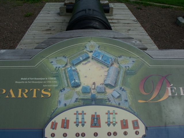
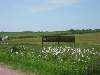
Historic fortification overlooking the Tantramar Marshes and Cumberland Basin.
|
|
|
Type: Fortification
Status: Repurposed
Accessibility: Easy
Recommendation: check it out if you're nearby
|
|
|
|
|
|
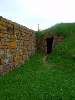
Casemates still intact as well as the officers' quarters which is now a museum.
|
|
|
|
|
|
|
|
|
France responded to the construction of Fort Lawrence in November 1750 when the Governor of New France, Jacques-Pierre de Taffanel de la Jonquière, Marquis de la Jonquière, issued new orders that a star-shaped fortress be built on Beauséjour Ridge. Work on the French fortress did not begin until the following spring, but by April 1751 construction was underway. Construction was slow, and the fort was yet incomplete when attacked in 1755 (Hand, 22). It was nonetheless a more substantial construction than Fort Lawrence, given its earthworks. In 1753, Le Loutre and the Acadians began to build a Cathedral just outside the fort.
At about the same time, two satellite forts, Fort Gaspareaux and Fort Menagoueche, were established to shore up the French defenses of Acadia. For four years, Fort Beauséjour and Fort Lawrence kept watch across the frontier between French and British territory on the Isthmus of Chignecto until the outbreak of the French and Indian War.
Fort Beauséjour was among the northernmost and easternmost of a series of French forts in North America built along the Mississippi and Ohio valleys and in the Great Lakes to contain British expansion into French territory. These defensive works are believed to have contributed to the "claustrophobic feeling"[citation needed] that European-American colonists on the eastern seaboard complained of in being prevented westward expansion from the Appalachian Mountains. Their inability to expand westward contributed to British tensions and helped lead to the French and Indian War. The result was the downfall of France's colonial ambitions in North America.
On June 4, 1755 the British conquest of all of France's North American territory began when a force of British regulars and New England militia attacked Fort Beauséjour from Fort Lawrence under command of Lt. Col. Robert Monckton. Again, Le Loutre was joined in resisting the British by Acadian militia leader Joseph Broussard. The British-led force took control of Fort Beauséjour by June 16, 1755, after which they changed its name to Fort Cumberland. French priest Jean-Louis Le Loutre's last act of defiance was to burn the local Cathedral so that it would not fall into the hands of the British. For leading the resistance against the British occupation of Acadia, he was captured and imprisoned for eight years.
|
|
|
|
|
|
|
|
|
|
|
|
|
The moderator rating is a neutral rating of the content quality, photography, and coolness of this location.
This location has not yet been rated by a moderator.
|
|
 This location's validation is current. It was last validated by
Opheliaism on 7/5/2010 1:41 AM.
This location's validation is current. It was last validated by
Opheliaism on 7/5/2010 1:41 AM.
|
|
|
on Jul 5 10 at 1:41, Opheliaism validated this location
on Jul 5 10 at 0:35, Jonnie B added some pictures to a gallery
on Jul 5 10 at 0:27, Jonnie B updated gallery July 4th stop
on Jul 5 10 at 0:26, Jonnie B created a new gallery
on Jun 30 10 at 12:53, tribeachpunk validated this location
on Jun 30 10 at 1:43, Steed conditionally validated this location
on Jun 30 10 at 0:15, nootz made this location available
on Jun 30 10 at 0:15, nootz updated gallery picture Cannons
on Jun 30 10 at 0:14, nootz updated gallery picture Cannons
on Jun 30 10 at 0:12, nootz updated gallery picture Ruins
|
|
|
|
|
|
|
Is this location inappropriate / broken / missing key info?
If it's something you can fix, please scroll up and click the EDIT button.
If this location was only posted a few days ago, give the creator time to work on it.
Please try sending a message directly to the creator of the location. You'll find that info at the top of this page.
Otherwise, ONLY if you've already tried to contact the original creator,: Click here to notify an administrator.
|
|
|
|
All content and images copyright © 2002-2024 UER.CA and respective creators. Graphical Design by Crossfire.
To contact webmaster, or click to email with problems or other questions about this site:
UER CONTACT
View Terms of Service |
View Privacy Policy |
Server colocation provided by Beanfield
This page was generated for you in 296 milliseconds. Since June 23, 2002, a total of 740493747 pages have been generated.
|
|