| Posted by nostra-YOUPPI! |
8/5/2005 4:59 PM | remove |
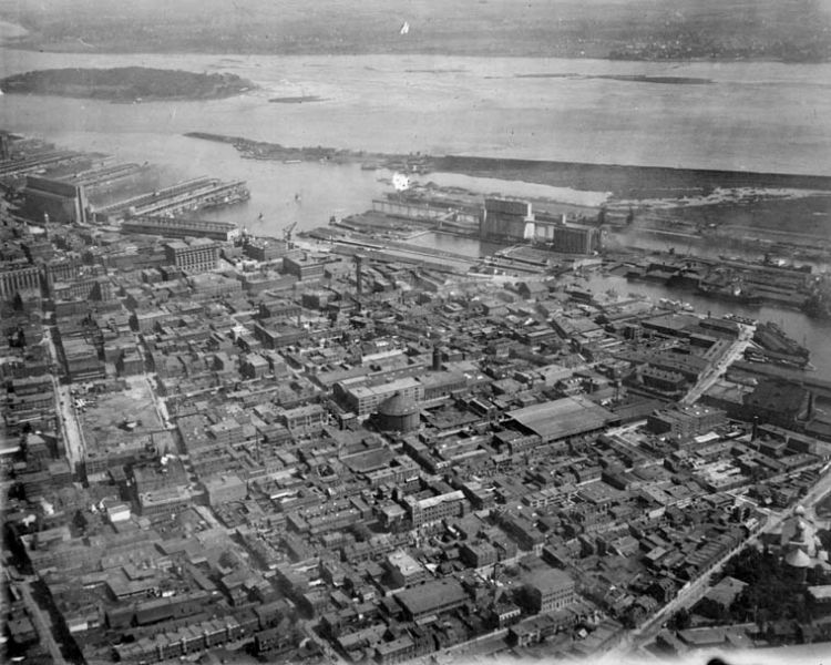
notice ste annes church on the right,
|
 |
| Posted by maZe |
8/5/2005 6:48 PM | remove |
what's the round structure in the middle?
|
|
| Posted by Emperor Wang |
8/5/2005 7:01 PM | remove |
Whatever it was, it's long gone. My port map from 1940 shows it still standing.
And what's with the vacant lot at left? Is that the beginnings of the freight terminal north of ETS?
|
|
| Posted by nostra-YOUPPI! |
8/5/2005 9:24 PM | remove |
actually the freight terminal north of the ETS has been railway property for a lot longer, it is on the site of the former bonaventure station, Peel street didnt run between st-james and notre dame until bonaventure station was pulled down. the yard of bonaventure station ran all the way to rose de lima, it was a railway yard for over a hundred years, it is just to the left of this picture. the only remaining land from the yard are the space around lionel groulx metro. until late in the 80s there was still an overpass on lucien lallier and mountain streets over this "yard" CN messagerie built the present building not long after bonaventure station was torn down, it was built to the west of the original station building to allow peel street to join. bonaventure station was built in 1847 serving the grand trunk (present CN)
http://collections.ic.gc.ca/cnphoto/archives/anglais/grand-trunk/43550.html
the building in the pic is siting where peel street is now. When you think about the placement, the Queens Hotel was probably the best situated in the city, smack dab between the CP
s windsor station and the Grand Trunks Bonaventure station
|
|
| Posted by nostra-YOUPPI! |
8/5/2005 9:26 PM | remove |
i went and looked at some maps, that vacant lot is the area now occupied by the CN viaduct and police station
|
|
| Posted by Emperor Wang |
8/5/2005 10:15 PM | remove |
Yeah, the area from des Seigneurs to Peel used to be pretty much plastered with railway tracks. That 1940 port map shows the only way to get around them were bridges that carried Guy and Mountain streets over the tracks. The bridges must have lasted sometime into the 60s as I can actually remember crossing one of them to go to the port with my old man.
Re the round thing, I've got a 1903 map that labels it (the low square building just south of it actually) as "Montreal Gas Co. Works", so it's probably a holding tank of some sort.
|
|
| Posted by nostra-YOUPPI! |
8/5/2005 10:37 PM | remove |
they were there in 1989 :) i remember them! the round building is a coke shed
|
|
| Posted by maZe |
8/5/2005 11:52 PM | remove |
coke shed? Still standing???
|
|
| Posted by Emperor Wang |
8/6/2005 12:13 AM | remove |
Nope, I snorted it all! :-)
In case anyone's curious, here's a link to the port map I mentioned. A nicely annotated guide to our fair city of 65 years ago.
West end:
http://www4.bnquebec.ca/cargeo/high/TRBA0174a_n.jpg
East end:
http://www4.bnquebec.ca/cargeo/high/TRBA0174b_n.jpg
|
|
| Posted by Emperor Wang |
8/6/2005 12:21 AM | remove |
And this one sheds a little light on the history of the round structure.
http://www4.bnquebec.ca/cargeo/high/TRAS0020_n.jpg
|
|
| Posted by maZe |
8/6/2005 3:17 AM | remove |
so it would be the "gazometer" ?
|
|
| Posted by Emperor Wang |
8/6/2005 3:43 AM | remove |
Yuppers, girl... "A storage container for fuel gas, especially a large, telescoping, cylindrical tank. Also called gasometer", according to dictionary.com.
|
|
| Posted by nostra-YOUPPI! |
8/6/2005 5:29 AM | remove |
i stand corrected on the round thing, the gazometers i am used to seeing are like the 2 that used to be at lasalle coke, they were approximately around the location of loblaws, they had flat tops and a structure that was taller than the tank when empty
|
|
| Posted by maZe |
8/6/2005 4:55 PM | remove |
so the place is definitely gone cause I have never seen it in my life... :(
|
|
| Posted by nostra-YOUPPI! |
8/6/2005 5:26 PM | remove |
the gasworks building next door to it is still there, i never realized there was actualy a gasworks downtown, these things stunk, so they would put em in the country (lasalle coke)
|
|
| Posted by Emperor Wang |
8/6/2005 8:37 PM | remove |
Here's a little better look at the round thing. I stumbled onto this while surfing McCord for images of old power generating stations.
http://www.mccord-museum.qc.ca/largeimages/V2941.JPG
The building just behind and to the right is where they keep the caleche horses, isn't it?
|
|
| Posted by Charlie_Dunver |
3/27/2006 3:07 AM | remove |
It was really sad and kind of bone chilling when the Mountain and Guy street bridges went down in the 80's. The railroad had been pulled up and it was this really weird empty space. They were dirt roads for a bit too never having had any pavement at ground level before. There were a lot of alternatives to what they could do there so feel free to look and think, " Is somebody fucking kidding?"
|
|
| Posted by nostra-YOUPPI! |
3/27/2006 3:26 AM | remove |
the new molson ex commercial makes me laugh with those guys sitting on green grass in 1903 and the bell centre was built around them. too funny considering that windsor station predates 1903
|
|
| Posted by maZe |
3/27/2006 4:00 AM | remove |
That pic actually shows why La ronde was named La Ronde... it's cause l'Île Ronde is actually round. YEAH. (sorry, so much exciting for not me... Argh, me and Expo 67).
|
|
| Posted by nostra-YOUPPI! |
3/27/2006 4:05 AM | remove |
we dont see ile ronde in this pic maze thats ile ste helene, ile ronde was barely an island basically a large mud flat
|
|
| Posted by Charlie_Dunver |
3/27/2006 4:08 AM | remove |
well, I can just picture the expo express going over there.
|
|
| Posted by Charlie_Dunver |
3/27/2006 4:09 AM | remove |
Cite Du Havre doesnt look like that big of a deal does it?
|
|
| Posted by maZe |
3/27/2006 4:10 AM | remove |
Oups. Rignt. Sorry.
|
|
| Posted by nostra-YOUPPI! |
3/27/2006 4:12 AM | remove |
that whole area previous to expo and the seaway was not very deep, subject to ice blocks and very muddy. if you look at pics of the spring floods chunks of ice got as far as the present site of the planetarium
|
|
| Posted by mewthree |
10/26/2007 4:13 PM | remove |
Posted by nostra-YOUPPI! 8/6/2005 5:24 AM | remove
actually the freight terminal north of the ETS has been railway property for a lot longer, it is on the site of the former bonaventure station, Peel street didnt run between st-james and notre dame until bonaventure station was pulled down. the yard of bonaventure station ran all the way to rose de lima, it was a railway yard for over a hundred years, it is just to the left of this picture. the only remaining land from the yard are the space around lionel groulx metro. until late in the 80s there was still an overpass on lucien lallier and mountain streets over this "yard" CN messagerie built the present building not long after bonaventure station was torn down, it was built to the west of the original station building to allow peel street to join. bonaventure station was built in 1847 serving the grand trunk (present CN)
http://collections...d-trunk/43550.html
the building in the pic is siting where peel street is now. When you think about the placement, the Queens Hotel was probably the best situated in the city, smack dab between the CP
s windsor station and the Grand Trunks Bonaventure station
Bonaventure station was a GTR railway station.
|

 order your copy of Access All Areas today!